Day 1 – Desfiladero de la Hermida
The first day we were doing the route in Desfiladero de la Hermida – the largest canyon in Europe. The route starts next to Deva river, flowing down from Fuente De. At first we went along the road till we reached the trail head. The trail is really nice, as the first and last stretches go along mountain streams. There were even a couple of waterfalls next to the path and a group of people doing canyoning.


Soon we got to a more closed woody path. The trail got quite steep at some points, but then it flattened out. We were getting close to the peak of the day, but the Mythological trail awaited us first. Here we found several examples of local folklore creatures, many of them quite perverted.


Eventually we reached the peak and the Mirador de Santa Catalina. The views from here are spectacular, as you get to see the whole valley below, both on the left and on the right. The villages down in the canyon were quite a pleasant sight as well. We could also observe many vultures flying around, above and below us. This was also the perfect spot to stop and have lunch.


It was time to head down. First we walked along the same mythological trail, later turning towards the pretty village of Cicera. Here we joined the Camino Lebaniego for a while. This is a detour from Camino Norte, which takes pilgrims off the Northern coast and into the Picos de Europa mountain, with Santo Toribio monastery serving as the finishing point.
The final part of the trail went down along the Cicera creek. The stream also forms several waterfalls on its path. At one point we spotted a small natural pool, and despite cool air temperatures (around 20 degrees Celsius) went for a quick dip. This freshened us up, right before the end of the route.


Day 2 – Bajo los Picos
It would be more fair to call this day Bajo las Nubes, as the clouds were covering all the sky and the mountains in the morning. Nevertheless, we went to Mogrovejo and set out to hike. One of the main attractions of the first part of the hike was a tractor going back and forth, bringing hay down to the village. The tractor also made the trail quite muddy at spots, so alternative paths or ways to go through had to be found.


Soon, we started hearing noises, which sounded like either a waterfall or a helicopter. The source was neither of those, but just another creek. At this point we had to cross several of them. Unlike last year’s trip, nobody fell into the water this time. Still, the peaks were nowhere in sight.


Towards the end of the hike the sky started clearing out a bit, and we got some nice views of the villages below. We actually passed through some of them, namely Tanarrio and Redo, and of course looping back to Mogrovejo. Finally, right before we finished the hike, the clouds started to disappear, giving us the chance to gaze at the peaks overhanging the trails we’ve just done.
We stopped for some snacks/lunch after the hike and had some rest. A part of our group decided that they haven’t had enough activities for the day and went to do a vía ferrata, located nearby in Camaleño.


Day 3 – Llanes
The third hiking day was a day for change of scenery. We left the natural park to go the Cantabrian coast and walk along it from Llanes. The contrast between Picos de Europa mountains and rugged Asturian coast is pretty big. This was also the only day of the journey when it properly rained. That being said, we managed to hide from the rain in a bar and by the time we got out for the day’s hike, the rained stopped and just 30 minutes later it even got sunny.


After the initial, somewhat crowded part, we got on to green trails, accompanied by one of the symbols of Asturias – cows. The green grassy trails were very pleasant to walk on. Meanwhile we were observing the sea on one side and the mountains (although mostly covered by clouds) on the other. At some point we stumbled upon a local guide, who told us that it was better not take the coastal trail and go a bit inland, which we did.


That said, we got close to the sea very soon again, as we came out to the Poo Beach. Despite the name, the spot is very scenic, since here you get to observe how the Vallina river makes its way into the sea, forming a couple of attractive beaches.


Eventually, we came back to a more rugged coast. Not only are there several cliffs here, but also a couple of small islands, which you can almost reach out and touch from the beach. To the excitement of many members of our group, the trail joined the Camino Norte here. The yellow arrows marked our way for a couple of kilometres, leading us to Celorio, where we ended the day with surfing.


Day 4 – Pico Gilbo
This day we were leaving Picos de Europa again, but for a very good reason. Even though the Gilbo peak in Riaño is not within the borders of the national park, it is one of the most spectacular hikes you can do in Castilla y León. The hike started from the Riaño reservoir, and it was clear from the beginning that it was going to be epic. The peak is visible from the bottom, and it seemed impossible that we would be able to get up, just judging by how steep and pointy it is.


At first the trail goes along a flat path, circling the reservoir. After a while it got really steep though, and stayed like that all the way till the peak. First we were going up through the woods, later finding an opening and continuing the hike with increasingly better views below us.


The final part of the ascent got really rocky and also dusty. I was quite surprised with how many people were doing this ascent. The crowds were mostly noticeable here, since the steepness of the trail made people stop for rest several times during the ascent. Eventually, all of us reached the peak and we made a long stop to have lunch and take some epic photos, posing on the edge.


To go back down we took a different path, which was also slightly less steep. By this point it got quite hot, so we decided to take a dip in the reservoir, that has been tempting us with its blue waters the whole day.


Day 5 – Horcados Rojos
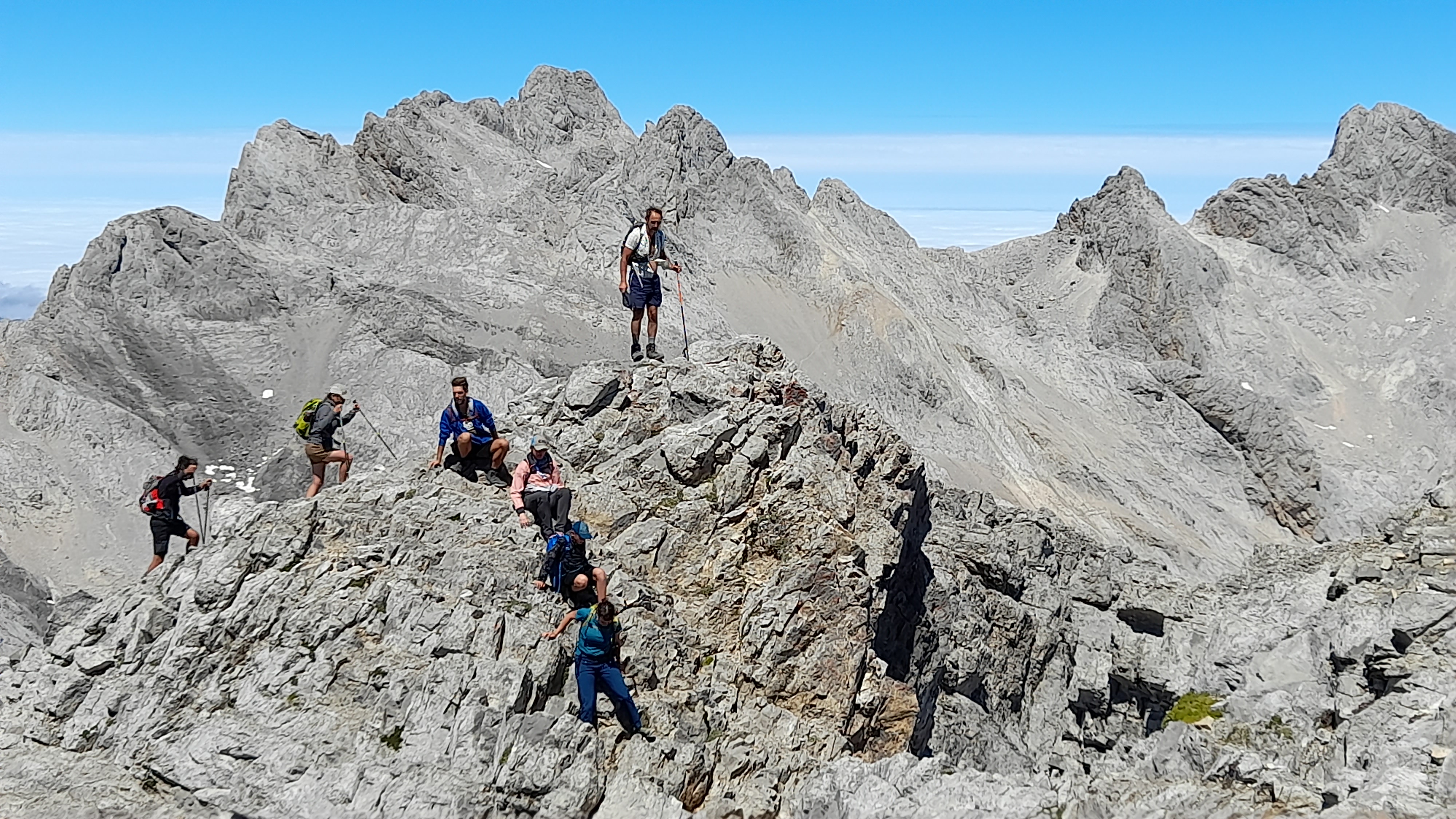
And for dessert we had the most impressive hike in Picos de Europa with an easy access – the Horcados Rojos trail. The forecast for the day did not look too happy, and indeed the skies were mostly covered by clouds in the morning. Our hopes were that we would get so high, that the clouds stayed below us. The cable car looked promising at first, but as we got to the top, we discovered that the clouds are still there. The visibility here sometimes did not surpass 20 meters, which gave the hike start quite an eerie feeling.


Thankfully, after about 30 minutes of walking, clouds did start to clear out. As we were getting higher and higher, the cloud cover was being left behind and splendid views of imposing rocks opened. Here we could not only see the bare rocks, but also several snow patches still not affected by summer sun. As we were getting closer to the mountain pass – Collado de Horcados Rojos, the chilly wind was getting stronger. However, this did not stop some members of our group walking shirtless.


Eventually, we reached the mountain pass and although the sign said “The End of the Trail”, we were willing to go further. That is because it is possible to continue from this point and (after some light scrambling) get to the Torre de Horcados Rojos peak.


The peak, at 2506 meters above sea level, provides splendid views of the surrounding area. On one side we got to see the entire trail that we just did, and on the other – the famous Pico Urrielu, more commonly known as Naranjo de Bulnes. As usual, this was a perfect stop for lunch and a long rest stop.
The way down goes along the same trail, and interestingly enough, the clouds we still covering the area around the cable car. After waiting in line for a short time, we got in and we back down.


This was my second trip to Picos de Europa and I enjoyed it a lot. Even after multiple visits, the place is still calling me to come back, and I am already looking forward to coming here again next summer.


Leave a Reply